






Close Air Support: Afghan Theater Vocabulary (2/2)
Following our previous look at the residential and defensive structures, we can now shift our focus to the natural and semi-artificial features of the Afghan landscape: water and vegetation.
To better appreciate the environment on the ground, I recommend the attached footage of a date orchard in Nangarhar. It captures the atmosphere of the "green zones" perfectly: areas of dense vegetation and activity that stand in stark contrast to the surrounding arid terrain. For those seeking a perspective of the country beyond the narrow lens of conflict, the "Sunrise Afghanistan" channel provides an invaluable look at the region's inherent beauty and geographic diversity!
II. Water features & Vegetation
II.1 - Karez
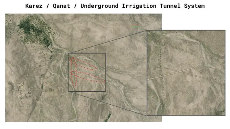
The Karez (a term preferred over "Qanat" to avoid phonetical confusion with "Qalat" during radio transmissions) is an ancient and sophisticated underground irrigation network found throughout the Persian region. From the cockpit, a Karez is one of the most distinct features of the landscape, appearing as a perfectly straight line of uniform mounds that resemble a string of bomb craters. These are actually vertical access shafts used for cleaning and maintenance. Conversely, we can note that from a ground perspective, these terrain features are poorly distinguishable.
Tactically, the Karez represents a significant subterranean threat. The larger systems are tunnels of sufficient size to conceal the movement of personnel and light equipment entirely out of view of aerial sensors. They can serve as infiltration routes or caches, allowing an enemy to displace between compounds or "vanish" after an engagement without ever crossing open ground.
In the DCS World environment, the karez systems are not modeled. Instead, they are represented through the overlying satellite imagery. Where the texture resolution is sufficiently high, these networks become visible to the pilot as a distinct series of circular shadows.
II.2 - Wadi
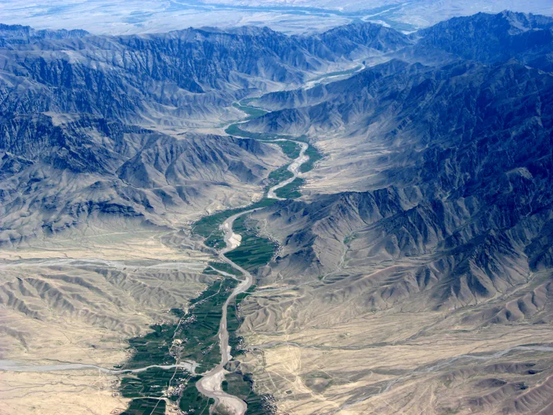
A Wadi is a dry riverbed. It can also serve as a transit corridor. Depending on their scale, wadis are utilized for the movement of both PAX and vehicles. Deep wadis offer excellent topographical concealment, masking visual profiles from ground-level observation. When a wadi is heavily utilized, vehicle tracks are often clearly visible in the soft ground, providing a clear indicator of activity to sensor operators.
Notably, wadis are generally considered safer from a legacy mine-threat perspective: mines from the Soviet era are less frequent in these washouts due to the shifting ground and seasonal water flow. However, they present a distinct environmental risk: during the rainy season, these dry beds can undergo "flash flooding," transforming into impassable torrents in minutes.
II.3 - Green Zone and Poppy Fields
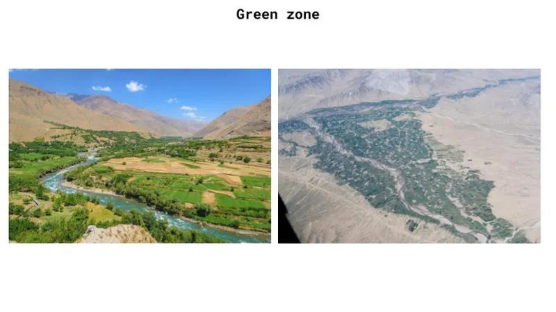
The "Green Zone" understandably refers to the fertile strips of land adjacent to rivers or irrigation sources. The density of vegetation here provides a challenging environment for CAS, as the canopy frequently masks firing positions and movement.
We can note that in DCS, the visual transition between the Green Zone and the surrounding arid terrain is somewhat more subtle than the stark, high-contrast boundary observed in real life. The game still provides a distinction, but the "wall of green" effect often found in reality, where lush, irrigated vegetation meets the desert floor is less pronounced.
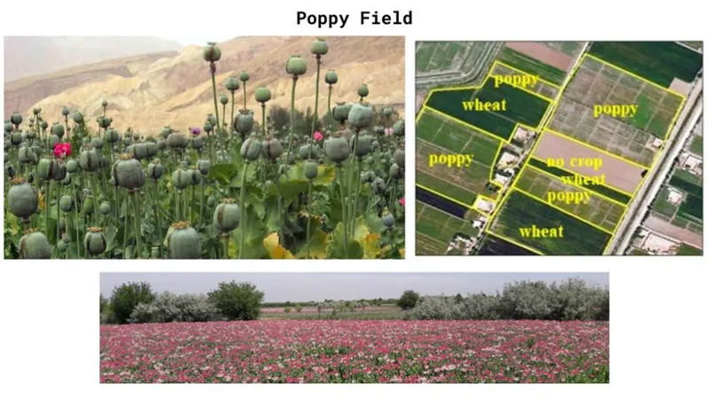
Within these green zones, poppy fields are a common agricultural feature. From high altitude, they are notoriously difficult to distinguish from wheat. However, during the blooming season, poppy fields take on a distinct pinkish or purple hue, whereas wheat fields remain a uniform, deep green.
Interestingly, poppy fields represent the visual inverse of a karez system. While a karez is a prominent visual landmark from the air but often just a series of mundane mounds on the ground, poppy fields are strikingly vibrant at eye level, especially during the blooming season when they explode into a sea of pink and purple. However, from a pilot's altitude, this distinct color often flattens and blends into the surrounding vegetation: they're just as common as any other surrounding cultivated field...
III. Various
III.1 - Jingle Truck
Although currently not modeled as a specific asset in DCS World, the "Jingle Truck" is an omnipresent feature of the Afghan landscape. These are highly decorated, brightly painted heavy trucks, often adorned with bells, chains, and intricate artwork (hence the name).
They represent the ultimate multi-purpose logistics platform in the Afghan theater. Their utility is total: some are fuel tankers, others are used to transport everything from bulk goods and construction materials to crops and livestock. Some of them also serve as buses for long-distance civilian travel.
Given their iconic status and the depth they would add to any mission, perhaps one of our readers would like to incorporate a set of jingle truck as a civilian vehicle add-on for DCS???
III.2 - The Ring Road
The Afghanistan Ring Road, also called "Highway 1" is the strategic logistical backbone of Afghanistan: it's the primary paved road that connects the nation’s major cities: Kabul, Kandahar, Herat, and Mazar-e-Sharif. While we call it a "highway", by Western standards, it is primarily a two-lane paved road, occasionally expanding to four lanes. However, in a country where the vast majority of the road network consists of unpaved tracks, this asphalt road is a major strategic asset, that has to be tightly monitored and controlled. In military terms, it is called a GLOC, or Ground Line of Communication.
We can note that the Ring Road is the primary interface between Afghanistan and its neighbors. In particular, the highway provides direct access to Pakistan via the border crossings at Spin Boldak in the south and the Khyber Pass in the east. Herat serves as another strategic node, being a gateway to both Iran and Turkmenistan.
It's also worth noting that the Ring Road is incomplete: the northwestern segment between Mazar-e-Sharif and Herat was never fully finalized. In this sector, the "highway" dissolves into unpaved tracks that are significantly more difficult to drive.
III.3 Shura and Jirga
While very common in the Afghan context, it's important to note here that you will probably only encounter these terms of "Shura" and "Jirga" in a JTAR/ASR, during your pre-flight planning phase, rather than during a live "talk-on."
Though often used interchangeably, these terms carry specific regional and ethnic weight:
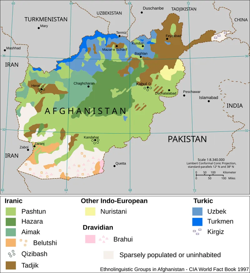
Jirga: it's a Pashto word meaning "gathering" or "consultation." While the practice has spread across Afghanistan, the Jirga is inherently rooted in Pashtun tribal tradition: these are highly formal events governed by the Pashtunwali (the tribal code of conduct). In a Jirga, elders sit in a circle: this specific geometry is intentional, since it is designed to dissolve any perception of inequality among the participants. A Jirga is gathered to resolve local or national conflicts. Decisions are reached through consensus or majority vote, and the resulting settlement is legally binding for all parties involved.
Shura: in regions dominated by non-Pashtun ethnicities, such as the Tajiks and Uzbeks in Northern and Western Afghanistan, this type of consultative gathering is instead referred to as a Shura. It serves a similar purpose: local leadership meeting to resolve community issues or coordinate with external entities, but it lacks the specific Pashtunwali formalism.
It is important to note that Shuras/Jirgas were not exclusively internal civilian affairs: military ground commanders were frequently invited to these gatherings to discuss security, development, or local grievances. Because these meetings could represent a high-concentration of both tribal elders and coalition leadership, they were prime targets for insurgent disruption. As a consequence, these events often justified a dedicated request for Air Support (oversewatch or show of presence), which is why you can regularly see them listed in a JTAR/ASR.
Conclusion
Understanding the specific vocabulary or the nuances of the Afghan landscape is more than a technical exercise for pilots: it is the first step toward a deeper cultural understanding of life in Afghanistan. As noted in countless after-action reports and "lessons learned" from decades of conflict, socio-cultural intelligence is as important to the success of a COIN mission as the pure fighting ability.
For those interested in further developing their cultural knowledge, ISAF and U.S. forces have published numerous guides detailing the specificities of Afghan culture, tribal dynamics, and the "human geography" of the theater. One example is attached below.
Dates orchard garden - Palm trees and children Life in Nangarhar afghanistan - HD (YouTube)