


ISAF 2009-2013 - ACO Building - Civilian Flight Rules (10/x)
In the early stages of the conflict in 2001, the Afghan airspace was almost entirely closed to civilian traffic. International airlines rerouted their flights to avoid the region, and the sky was used primarily by military aircraft.
By the 2009–2013 period, the situation had changed. The military campaign tried to enter a "normalization" phase. During this time, in the air the goal was to allow civilian and commercial aviation to return to Afghanistan while maintaining active military operations. This created a complex environment where high-performance fighter jets, transport aircraft, and international airliners all had to share the same limited airspace.
To manage this, the military Airspace Control Authority (ACA) implemented a specific set of rules based on international standards but adapted for the geographical and operational requirements of the country.
We will try to explain here the fundamental IFR (Instrument Flight Rules) and VFR (Visual Flight Rules) regulations used in the Kabul FIR (Flight Information Region) during this period.
I. Airspace Description
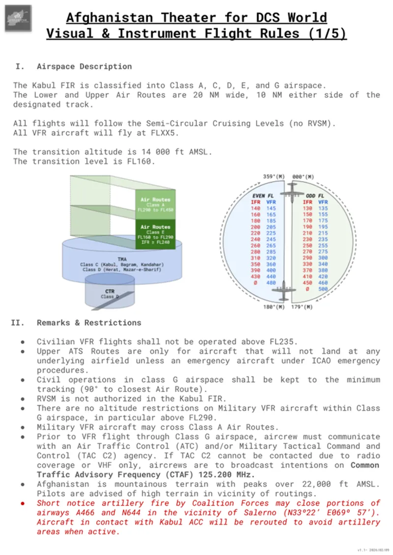
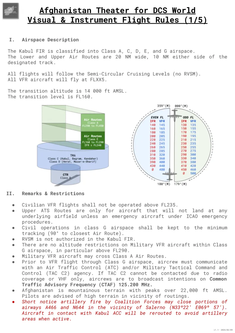
The Kabul FIR is divided into Class A, C, D, E, and G airspace to organize the various types of traffic flow. We can note that both Lower and Upper Air Routes are defined as 20 NM wide, extending 10 NM on either side of the designated center track.
Vertical separation is managed through the mandatory use of Semi-Circular Cruising Levels. It is important to note that RVSM (Reduced Vertical Separation Minimum) is not authorized in this region, meaning a standard 2,000 ft vertical separation applies to all IFR flights above FL290.
To ensure separation from IFR traffic, VFR aircraft are required to fly at "plus 500" levels, such as FL165 or FL185.
Due to the extreme mountainous terrain and the height of the Hindu Kush, the transition altitude is set at 14,000 ft AMSL, with the transition level is at FL160.
In uncontrolled Class G airspace, civilian aircraft must join the closest controlled air route as directly as possible, typically by tracking at a 90° angle to the route, to avoid interfering with military activity.
II. Remarks and Operational Restrictions
II.1 - Traffic Separation and Route Restrictions
To prevent interference between different types of flight operations, specific restrictions were applied based on the nature of the flight. Civilian VFR aircraft were restricted to a maximum altitude of FL235. In particular, this kept low-level traffic clear of the primary en-route structures used by high-altitude international carriers. This type of rule is very common in most countries. For example, in France VFR is not allowed above FL195.
However, you will note that military aircraft may fly in a "see and avoid" mode above FL235. In that case, during transit phases, it's recommended to use a "VFR" flight level (245, 255, ..., 300, 320, etc...) in order to remain clear of potential civilian IFR aircraft, especially near existing air routes.
The Upper ATS Routes served a very specific purpose: they were dedicated exclusively to aircraft transiting through the Kabul FIR. Unless an aircraft was declaring an emergency under ICAO procedures, it was strictly prohibited from landing at any underlying airfield if it was operating on these upper routes. This separation ensured that heavy transit flow did not conflict with the arrival and departure patterns of major hubs like Bagram or Kandahar.
II.2 - Procedures in Uncontrolled Airspace
We can note that most of the Afghan airspace was Class G (uncontrolled) airspace. While civilian aircraft were required to minimize their time here and join controlled routes as directly as possible, military aircraft operated there with significant freedom. As noted above, military flights had no altitude restrictions within Class G, even above FL290, and were authorized to cross Class A Air Routes provided they maintained VFR separation.
Due to limited radar coverage, communication was the primary tool for safety in these uncontrolled sectors. Pilots were required to contact a Military Tactical Command and Control (TAC C2) agency before leaving controlled airspace. In areas where radio coverage was limited, the standard procedure was to broadcast all intentions on the Common Traffic Advisory Frequency (CTAF) of 125.200 MHz.
II.3 - Environmental and Operational Hazards
Navigation in Afghanistan requires particular attention to the physical environment: the terrain has peaks exceeding 22,000 ft AMSL and pilots have to remain vigilant for high terrain in the immediate vicinity of all routes, in particular because all flight levels were not usable on every portion of the routes. You need to note that the minimum indicated flight level is FL160, but this altitude does not guarantee clearance with the ground in every portions of the lower ATS routes. Several civilian aircraft crashes directly resulted from an inability to to maintain adequate clearance from terrain (also called CFIT: Controlled Flight Into Terrain).
In addition to the geography, the tactical situation could change the airspace structure rapidly. The most significant example is linked to coalition artillery fire. It was a frequent occurrence, and as we'll see in a future article dedicated to that topic, artillery shells can fly above FL400 and are a real danger to aircraft navigation, so much that a special warning had to be published for flights in the vicinity of FOB Salerno. In this case, the surface-to-surface fires could result in the immediate closure of portions of airways A466 and N644!
III. Comparison with Western Standards
While the Afghanistan AIP is structured according to international civil aviation guidelines, several key differences exist when compared to the airspaces of Western Europe or North America.
III.1 - Transition Altitude and Altimetry
In most Western countries, the transition altitude (i.e. the altitude at which pilots switch their altimeter setting from local pressure (QNH) to the standard setting (29.92 inHg / 1013 hPa)) is typically quite low, often between 3,000 and 6,000 ft AMSL. In Afghanistan, this is set significantly higher at 14,000 ft AMSL. This ensures that aircraft remain on a consistent pressure setting while operating well above the majority of the mountainous terrain, providing a safer margin for separation in a region where many peaks exceed 10,000 ft.
III.2 - Vertical Separation and RVSM
The most notable difference for en-route operations is the absence of Reduced Vertical Separation Minimum (RVSM). To male it short, in modern Western airspaces, RVSM allows modern aircraft to fly with only 1,000 ft of vertical separation between FL290 and FL410. In the Kabul FIR, this was not authorized. All aircraft were required to maintain 2,000 ft of separation above FL290. This significantly reduced the number of available "slots" for transit traffic, making the management of the East-West corridor much more rigid than the flexible high-altitude environments found over the Atlantic or mainland Europe.
III.3 - Dynamic Airspace Management
Finally, the concept of an airway being closed on short notice due to ground-based artillery fire is a factor that civilian pilots in the West never encounter. Even during major exercises, the NOTAMs closing portions of airspace are published days or weeks before the flight, and it's very rare to face an unexpected airspace closure. In the Kabul FIR, the transition from a standard transit flight to an active reroute due to kinetic activity was a standard part of the operational routine, requiring pilots to maintain a higher level of awareness than in a more conventional civilian environment.
III.4 - Radio and Radar Coverage Gaps
Another significant difference with Western norms is the lack of comprehensive radar and radio infrastructure. In Europe or the USA, pilots are almost always under positive radar control with continuous VHF contact. In the Kabul FIR, radar coverage was limited, and radio "blind spots" were common due to the high terrain. Pilots frequently encountered a total loss of communication with ATC, a situation that Western pilots generally only experience during long-range transoceanic flights. This situation requires a higher degree of discipline in following "procedural" separation and adhering strictly to the published routes and timings.
Conclusion
Operating within the Kabul FIR required (and still requires!) a blend of discipline to follow procedures and heightened situational awareness. The "normalization" of the airspace allowed for the return of international commerce, but it placed a higher responsibility on all pilots in an environment with such limited radio and radar coverage.
For the DCS pilot, while these rules might seem secondary to their operations, they provide a necessary layer of realism. Whether you are flying a strike mission or a transport sortie, understanding the limitations and procedures that civilian traffic must follow is essential for better airmanship and a deeper understanding of the "big picture" in the Afghan theater.
Understanding the regulatory framework is only the first step. To effectively navigate this region, one must also understand the physical layout of the Afghan air corridors. In the next article, we will explore the Upper and Lower ATS structures.
Note: the primary reference for our current Airspace Control Order (ACO) is the May 2011 Afghanistan AIP (Edition 45), which is attached below. While we strive for maximum authenticity, you will notice certain deviations and simplifications from real-world procedures. These adjustments have been made to ensure interoperability with other existing airspace, like Air-to-Air Refueling (AAR) tracks, and to accommodate the specific constraints of the DCS World environment.
