

ISAF 2009-2013 - ACO Building - Upper and Lower ATS Routes (11/x)
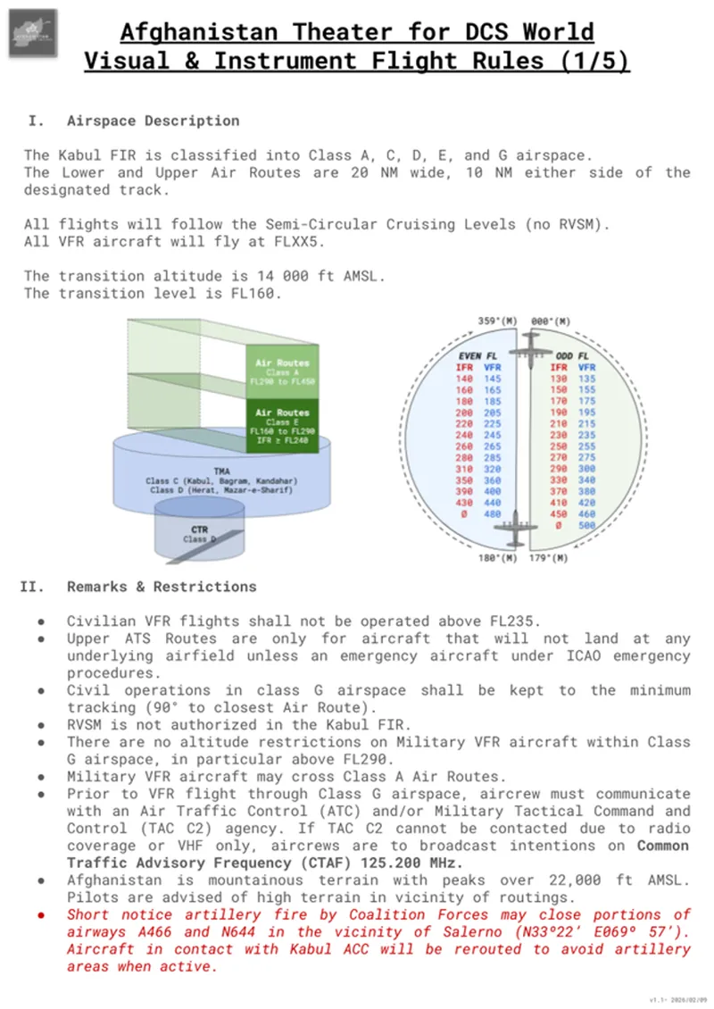
Following the civilian flight rules that we discussed in the previous article, we need to look at the standing air routes that cross Afghanistan. During the 2009–2012 period, these routes were busy. Even though a war was happening on the ground, the sky was a crowded place where combat jets and airliners had to live together.
It is important to remember that these air routes are mostly for civilian use. Combat pilots usually switch to operational traffic once entering the theater, meaning they follow military controllers and mission-specific rules. However, you will still see military planes on these civilian tracks. Strategic transports like C-17s coming directly from the other continents, tactical C-130s moving supplies between bases, and even tankers can use them to reduce TAC C2 controllers' workload.
I. The Lower ATS Routes
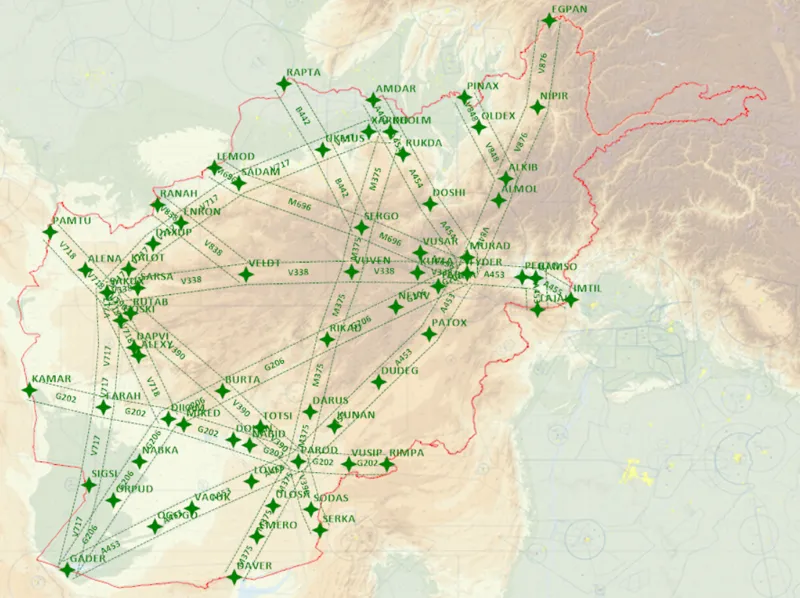
The Lower ATS routes are the local roads of the Afghan sky. They connect the major bases and airports like Kabul, Bagram, Kandahar, and Herat: you see that "nodes" in the lower ATS routes are generally located above civilian airfields.
These routes are mostly used by regional propeller planes, aid flights, and military transport aircraft. Because they are at lower altitudes, from 16,000 ft up to 29,000 ft, therelief is a huge factor. The Hindu Kush is unforgiving and in many areas, the "Minimum En-route Altitude" (MEA) is very high. You have to check your charts carefully: an altitude that is safe over Kandahar might run you right into a mountain further north.
These routes also connect to all the major airfields in Afghanistan, and they will only be used by aircraft departing or landing at one of these places. The transition from the local IFR procedures to the en-route transit should be planned following the published local procedures (note that ILS have not yet been modeled by ED on this theater).
Important: the previously published procedures and the ATS routes published here may not match perfectly (waypoint names or positions). The local procedures will be revisited in the future to ensure full coherence.
This is also where the "CTAF" frequency (125.200 MHz) is most important. At these lower heights, radar or radio often doesn't work because the mountains block the signal. Pilots have to talk to each other on the radio, announcing where they are so they don't run into anyone else, especially near small, remote dirt strips.
II. The Upper ATS Routes
The Upper ATS routes (from FL290 to FL450) are the international expressways. In 2011, these were some of the busiest air corridors in the world. They connect Europe and the Middle East to places like India and Thailand. A unique thing about these high-altitude routes in Afghanistan is that they almost all run East-to-West. Large airliners like Boeing 777s or Airbus A330s use them to transit across the country quickly. This keeps the fast, heavy traffic high up and away from the tactical flying happening near the airfields.
However, given the size of the theater, it is totally normal for a fighter jet to RTB above FL400, and since military movements will be primarily North/South (eg: Helmand to Bagram, or Nuristan to Kandahar...), you will cross several upper ATS routes and possibly fly close to civilian liners: look outside, fly at VFR flight levels, and if flying close to a liner, momentarily put your IFF mode 3/C off to avoid triggering a TCAS alert.
Conclusion
As a combat pilot on an operational mission, you probably won't use any of these routes. You might follow them when you are ferrying your jet into the country from a base in Europe or the Middle East, but that's probably the only instances you'll actively use them.
However, as a matter of safety and good airmanship, you still need to know exactly where these "highways" are. You need to keep a sharp eye out when you are climbing to meet a tanker or when you are transiting at high altitude. You will run into civilian airliners, especially near Kandahar or along those East-West tracks. And when things get "hot" in other parts of the Middle East, even more civilian planes crowd into Afghan airspace to stay safe...