


Who is this creator?
No community tags yet.
Worldpainter tiles - The United States of America - 1:250 scale -
Aug 27, 2024 0
Real World Maps - The United States of America - 1:250 scale
This work is a representation of the contiguous United States of America, part of Canada, Mexico, Cuba and Bahamas on a 1:250 scale for Minecraft Features Terrain elevation data from NASA DEM 30m (at 1:250 scale, however, it's really smoothed) Ocean/Sea, beaches, rivers and lakes from OpenStreetMap
Aug 27, 2024 0
Real World Cities - Warren County, VA, USA - 1:1 scale - 34k
This work is a representation of Warren County, VA, USA and neighbrood areas, on a 1:1 scale for Minecraft Features Real cities with in scale buildings, roads, footways, vegetation derived from OpenStreetMap (quality depends on data coverage) High resolution terrain elevation data from LIDAR sources
Aug 26, 2024 0
Worldpainter tiles - Warren County, VA, USA - 1:1 scale - 34k
Aug 26, 2024 0
Worldpainter tiles - El Paso, TX, USA - 1:1 scale - 47k
Aug 26, 2024 0
Worldpainter tiles - Vacaville, CA, USA - 1:1 scale - 12k
Aug 22, 2024 0
Real World Cities - Vacaville, CA, USA - 1:1 scale - 12k
This work is a representation of Vacaville, California, USA and neighbrood areas, on a 1:1 scale for Minecraft Features Real cities with in scale buildings, roads, footways, vegetation derived from OpenStreetMap (quality depends on data coverage) High resolution terrain elevation data from LIDAR sou
Aug 22, 2024 0
Real World Cities - Ocean City, MD, USA - 1:1 scale - 15k
This work is a representation of Ocean City, MD, USA and neighbrood areas, on a 1:1 scale for Minecraft Features Real cities with in scale buildings, roads, footways, vegetation derived from OpenStreetMap (quality depends on data coverage) High resolution terrain elevation data from LIDAR sources Oc
Aug 21, 2024 0
Worldpainter tiles - Ocean City, MD, USA - 1:1 scale - 37k
Aug 21, 2024 0
Real World Cities - Jackson, Mississippi, USA - 1:1 scale - 37k
This work is a representation of Jackson and neighbrood areas, Mississippi, USA, on a 1:1 scale for Minecraft Features Real cities with in scale buildings, roads, footways, vegetation derived from OpenStreetMap (quality depends on data coverage) High resolution terrain elevation data from LIDAR sour
Aug 21, 2024 0
Worldpainter tiles - Jackson, Mississippi, USA - 1:1 scale - 37k
Aug 21, 2024 0
TORR…
Real World Cities - Jersey City & Hudson County, NJ, USA - 1:1 scale - 11k
This work is a representation of Jersey City and the Hudson County, NJ, USA, on a 1:1 scale with buildings, roads, trees, and vegetation derived from OpenStreetMap. Individual trees within the cities will be present in-game, if traced on OpenStreetMap. In larger cities this often happens, and theref
Jul 24, 2024 0 1
Geotiff and Worldpainter data - Jersey City & Hudson County, NJ, USA - 1:1 scale [11k]
Jul 24, 2024 0
TORR…
Real World Cities - Hamilton, NY, USA - 1:1 scale - 8k
This work is a representation of Hamilton, NY, USA, on a 1:1 scale with buildings, roads, trees, and vegetation derived from OpenStreetMap. Individual trees within the cities will be present in-game, if traced on OpenStreetMap. In larger cities this often happens, and therefore it is possible to rep
Jul 24, 2024 0 1
Geotiff and Worldpainter data - Hamilton, NY, USA - 1:1 scale [8k]
Jul 24, 2024 0
Geotiff and Worldpainter data - Mississippi, USA - 1:20 scale [27k]
Jul 20, 2024 0
Geotiff and Worldpainter data - Hawaii, USA - 1:10 scale [51k]
Jul 16, 2024 0
Geotiff and Worldpainter data - Baden District, Austria - 1:1 scale [25k]
Jul 11, 2024 0
Geotiff and Worldpainter data - Kansas City, USA - 1:1 scale [45k]
Jun 17, 2024 0
Geotiff and Worldpainter data - St. George, Hurricane, Cedar City and Zion National Park (SW Utah, USA) - 1:3 scale - 46k
May 31, 2024 0
Geotiff and Worldpainter data - The United States of America - 1:88 scale [46k]
May 23, 2024 0
Geotiff and Worldpainter data - Vietnam, Cambodia, Laos & Thailand [43k] - 30m resolution
Apr 14, 2024 0
Geotiff and Worldpainter data - SW Utah - USA [34k] - 3m resolution
Mar 26, 2024 0
Geotiff and Worldpainter data - Maryland - USA [52k+] - 5m resolution
Mar 19, 2024 0
Geotiff and Worldpainter data - Adirondack Mountains, NY - USA [45k] - 5m res
Mar 11, 2024 0

MC Real World Maps - Japan 30m resolution [40k]
This map is part of the project of making real world maps in Minecraft using very high resolution geographic data, started recently with the release of Italy Map at 30m, Central Europe Map at 50m and Sydney City at 5m resolution. This time the work is focused on Japan, with a resolution of 30m, whic
Feb 28, 2024 0 391
Geotiff and Worldpainter data - Japan 30m resolution [40k]
Feb 28, 2024 0
Geotiff and Worldpainter data - Sydney 5m resolution [16k]
Feb 25, 2024 0
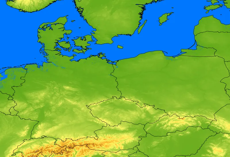
MC Real World Maps - Central Europe [38000x26000] - 50m resolution
Update V2.1 - 2024/02/13 [NEW!] - Added 40 JourneyMap waypoints for major cities, now you can't get lost! Update V2 - 2024/02/12 Better coastal regions, expecially over The Netherlands Added rivers and lakes made by real world Corine land cover data Better clay/sand layer made by real world Corine l
Feb 9, 2024 0 23
Geotiff and Worldpainter data - Central Europe [38000x26000] - 50m resolution
Feb 9, 2024 0
Geotiff and Worldpainter data - Italy [38000x46000] - 30m resolution
Feb 3, 2024 0

Ultra High Resolution real world maps in Minecraft
Hi everyone! I'm excited to introduce you to my new project on Patreon. I work in the field of meteorology, in particular in the development of very high resolution meteorological models, for this reason I find myself managing high resolution geographic and meteorological data of the Earth every day
Feb 2, 2024 0 5