



ISAF 2009-2013 - ACO Building - IFR & VFR Transit Trough Pakistan (7/x)
As we all know, Afghanistan is a landlocked country, isolated from direct maritime access and surrounded by sovereign states whose airspace immediately becomes a strategic factor in any sustained air campaign. At the outset of Operation Enduring Freedom (OEF) in late 2001, this geographic reality shaped every aspect of coalition air operations.
Before permanent basing could be established inside Afghanistan, transit through third countries was mandatory. Strike aircraft, tankers, ISR platforms, and carrier-based aviation all depended on carefully negotiated overflight agreements, diplomatic clearances, and tightly controlled corridors to reach the AO. Even once airfields inside Afghanistan became operational, the flow of combat power, logistics, command-and-control assets, and naval aviation support continued to rely heavily on long-range air transit routes.
Two primary access axes emerged during OEF:
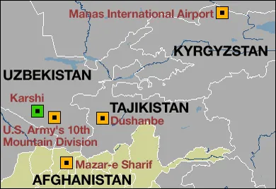
A Northern corridor, transiting through Central Asia via Manas airport (the U.S. Transit Center in Kyrgyzstan);
A Southern corridor through Pakistan, linking coalition airbases in the United Arab Emirates and Qatar, as well as carrier strike groups operating in the Arabian Sea, directly to Afghan airspace.
The southern route was both operationally indispensable and politically sensitive. Pakistani airspace was not a permissive environment in the tactical sense: it was governed by strict diplomatic constraints, predefined routing, altitude segregation, and mandatory coordination with Pakistani civil and military air traffic authorities. Deviations could become political events, especially because the support to US forces has always been a sensitive matter in Pakistan's internal politics.
To manage this complexity, coalition planners established, in coordination with Pakistani authorities, a separated transit systems through Pakistan. It evolved along time, to take into account the reality of operations on the ground. While during the initial strikes after 9/11 several corridors were in use, during the 2009-2013 period, a single one remained.
For those looking to recreate naval operations from the Arabian Sea in DCS, understanding and flying similar corridors correctly is definitely a nice touch to recreating OEF-era operations with credibility.
I. IFR Transit Through Pakistan
An IFR corridor was the most reliable and consistently used method of transiting Pakistani airspace during OEF. It was designed first and foremost to guarantee access to Afghanistan regardless of weather, while maintaining strict control in a politically sensitive environment.
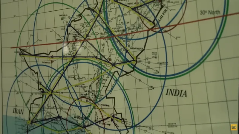
From an operational perspective, the primary strength of IFR transit was predictability. Such a corridor can be built around a fixed sequence of waypoints, using existing civilian waypoints, or creating additional ad-hoc waypoints if needed. Adding standardized reporting procedures, and vertically separated altitude blocks for northbound and southbound traffic would increase deconfliction in areas sometimes poorly covered by radars.
This structure allowed Pakistani air traffic control, particularly Karachi ACC, to manage a steady flow of coalition aircraft with minimal ambiguity. For aircrews, once cleared into the corridor, the mission became straightforward: hold the assigned flight level, fly the published routing, and report at each mandatory point.
If weather independence was the decisive advantage of the IFR transit, this came at the cost of autonomy. IFR transit through Pakistan placed coalition aircraft under the continuous control of Pakistani ATC: every request was subject to Pakistani ATC approval. Unlike permissive airspace or tactical control zones, there was no latitude for improvisation. Deviations for weather avoidance or spacing required coordination, and unauthorized maneuvering was not an option: for fighter crews accustomed to flexible routing and tactical discretion, this was a potential constraint.
In practice, the IFR transit through Pakistan was most often uneventful. For carrier-based crews in particular, this phase could serve as a mental decompression period before entering the far more demanding environment of naval operations. The relative monotony of the corridor allowed aircrews to reset and prepare mentally for the high workload associated with recovery to the ship.
II. VFR Transit Through Pakistan
Adding to the above IFR corridor an option to transit VFR offered an alternative to the rigid structure of IFR transit, trading procedural protection for increased aircrew responsibility. While still geographically constrained, the VFR transit places a greater emphasis on pilot judgment and self-separation within the published corridor limits. It was a viable option only when meteorological conditions allowed, but when available, it provided a markedly different operational experience.
The principal advantage of VFR transit was autonomy. Crews were not tied to continuous clearances and could manage spacing between formations more fluidly. For fighter packages, this greatly reduced radio workload and allowed large formations to remain intact over long distances. The corridor effectively worked as a controlled visual airway, predictable in shape yet flexible in execution.
That autonomy, however, was conditional. A VFR corridor demanded good weather and sufficient visibility to ensure continuous “see and avoid” capability. Poor weather could quickly invalidate VFR operations and force a reversion to IFR routing. Weather support provided by the military units like the 577th Weather Wing therefore became a primary consideration during mission planning.
For DCS pilots, the VFR transit is a nice way to replicate the responsibility of aircrews to operate autonomously, but never outside clearly defined limits...
Conclusion
With the decision to include the North Arabian Sea in DCS, the opportunity now exists to replicate naval air operations in support of Afghanistan operations. Recreating the transit over Pakistan is therefore a logical and necessary step for those seeking to recreate these operations accurately. Whether IFR or VFR, the transit was an integral phase of every sortie before reaching the combat zone.
The intent of this article is not to impose a single method, but to provide sufficient historical and procedural reference for mission designers and virtual squadrons to develop their own credible transit procedures. When properly integrated into mission design, these corridors add depth, context, and authenticity to Afghan-era scenarios, reminding us that realism is not only found in weapons employment, but also in the long, disciplined journey that preceded it.
100 Years of Air Traffic Control w ENG Subtitles | Mini Documentary | Junaid Akram (YouTube)
Comments (3)
Cool post 👍🏾
Great information! This is quite the long transit (>300nm one way), ist there any information on AAR right before/after the route through Pakistan? Would they maybe land in Kandahar after the transit and use a recovery tanker at the boat?
You can meet with the tanker in the corridor en refuel en-route, but no holding pattern for the tanker, just be on time at the rdv point. Or the other option is to refuel in Southern Afghanistan, on one of the usual tanker tracks as detailed earlier.