







What's new on EarthToMC v2.0 - Biomes O' Plenty & Terralith support, new biomes positioning system, high-res DEM for Europe, Canada and The Arctic - 2026/03/11
Download post:
EarthToMC v2.0-beta [2026/03/11] - Download and Installation tutorial | Patreon
EarthToMC v2.0 certainly is the biggest update of the software so far! The biome classification system has been completely redesigned, introducing climate data from WorldClim 2.1 and the newer, higher resolution GLC FCS 10 Land Cover dataset to make biome distribution more realistic and geographically accurate
New vanilla biomes have also been added, such as Jungle, Sparse Jungle, Bamboo Jungle, Savanna, Windswept Savanna, Old Growth Pine Taiga, Old Growth Spruce Taiga, Birch Forest, Cherry Grove, Grove, Windswept Hills, and Windswept Gravelly Hills.
On top of that, two of the most requested features are finally here: Biomes O' Plenty and Terralith mod support!
I've also added high-resolution DEM datasets for many European countries, Canada and the Arctic, with a massive improvement regarding the terrain elevation details for maps with scale < 1:10
New biomes classification system
In all previous versions of EarthToMC, biomes were assigned based almost entirely on the land cover class from the GLC FCS 30 dataset. This worked, but it meant that, for example, a forest in Finland and a forest in Brazil would often get the same Minecraft biome.
The new reference land use dataset is now GLC FCS 10, with a resolution 3 times higher than the previous one (GLC FCS 30)
In v2.0, the biome classification engine now combines three types of data:
1. Land cover class (forest type, cropland, water, urban, bare land)
2. WorldClim 2.1 bioclimatic variables (mean annual temperature, max/min monthly temperatures, annual precipitation)
3. Elevation from DEM (distinguishing mountain peaks, highlands, valleys, steep cliffs, flat plains)
This multi-layer approach means that biomes are now placed where they actually belong: jungles in the tropics, taigas in the boreal regions, savannas in warm semi-arid areas, cherry groves in Japan and Korea, and so on. The classification also uses Gaussian-filtered pseudo-random variation to create natural-looking rare biome patches instead of sharp, blocky transitions.
+20 new vanilla biomes
Thanks to the new climate-based classification, over 20 new vanilla biomes are now placed in the maps, bringing the total to 45 vanilla biomes available in Vanilla Minecraft. For reference, EarthToMC v1.9 uses only 25 biomes! Here's the list of the biomes used in EarthToMC:
Flower Forest - Forest - Mangrove Swamp - Lush Caves - Jungle - Sparse Jungle - Bamboo Jungle - Birch Forest - Old Growth Birch Forest - Dark Forest - Cherry Grove - Meadow - Plains - Swamp - Taiga - Savanna - Windswept Savanna - Sunflower Plains - Old Growth Pine Taiga - Old Growth Spruce Taiga - Snowy Taiga - Grove - Frozen Peaks - Windswept Hills - Windswept Gravelly Hills - Desert - Badlands - Wooded Badlands - Eroded Badlands - Beach - Stony Shore - River - Ocean - Warm Ocean - Frozen Ocean - Cold Ocean - Lukewarm Ocean - Deep Ocean - Cold Deep Ocean - Lukewarm Deep Ocean - Frozen Deep Ocean - Snowy Slopes - Snowy Plains - Frozen River - Snowy Beach
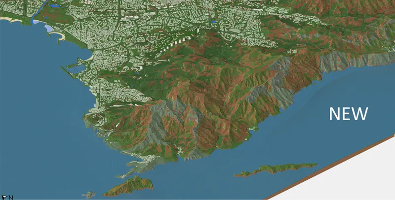
A 1:1000 scale world map with Vanilla Biomes
Biomes O' Plenty support
One of the most requested features since the beginning of EarthToMC is now here. In v2.0, you can select Biomes O' Plenty as the biome mod to use during map generation.
The BOP classification engine maps land cover and climate data to 44 unique Biomes O' Plenty biomes + 11 vanilla biomes (ocean ones), including:
Floodplain - Pasture - Prairie - Field - Grassland - Orchard - Lush Desert - Mediterranean Forest - Rainforest - Rocky Rainforest - Fungal Jungle - Tropics - Seasonal Forest - Forested Field - Maple Woods - Old Growth Woodland - Dead Forest - Fir Clearing - Snowy Fir Clearing - Coniferous Forest - Snowy Coniferous Forest - Redwood Forest - Muskeg - Snowy Maple Woods - Mystic Grove - Ominous Woods - Scrubland - Shrubland - Rocky Shrubland - Dryland - Lush Savanna - Bog - Highland - Highland Moor - Lavender Field - Tundra - Cold Desert - Bayou - Marsh - Crag - Dune Beach - Origin Valley - Auroral Garden - Wintry Origin Valley
Each biome is assigned based on the same multi-layer climate analysis used for vanilla, ensuring geographic accuracy.
A 1:700 scale America map preview with BOP biomes
Terralith support
Alongside Biomes O' Plenty, Terralith is also now fully supported with an even more detailed classification engine mapping to 62 unique biomes + 11 vanilla biomes (ocean ones), including:
Valley Clearing - Orchid Swamp - Steppe - Highlands - Lush Valley - Blooming Valley - Lush Desert - Granite Cliffs - Alpha Islands - Rocky Jungle - Amethyst Rainforest - Tropical Jungle - Temperate Highlands - Forested Highlands - Cloud Forest - Birch Taiga - Brushland - Snowy Shield - Snowy Maple Forest - Hot Shrubland - Shrubland - Rocky Shrubland - Arid Highlands - Moonlight Grove - Lavender Valley - Sakura Grove - Savanna Slopes - Wintry Lowlands - Gravel Desert - Ice Marsh - Alpine Highlands - Rocky Mountains - Warped Mesa - Desert Canyon - Frozen Cliffs - Glacial Chasm - Warm River - Sandstone Valley - Fractured Savanna - Savanna Badlands - Volcanic Peaks - White Cliffs - Jungle Mountains - Amethyst Canyon - Haze Mountain - Volcanic Crater - Siberian Grove - Moonlight Valley - Shield - Lavender Forest - Scarlet Mountains - Yellowstone - Mountain Steppe - Blooming Plateau - Emerald Peaks - Yosemite Cliffs - Painted Mountains - Sakura Valley - Snowy Badlands - Desert Oasis - Desert Spires - Mirage Isles
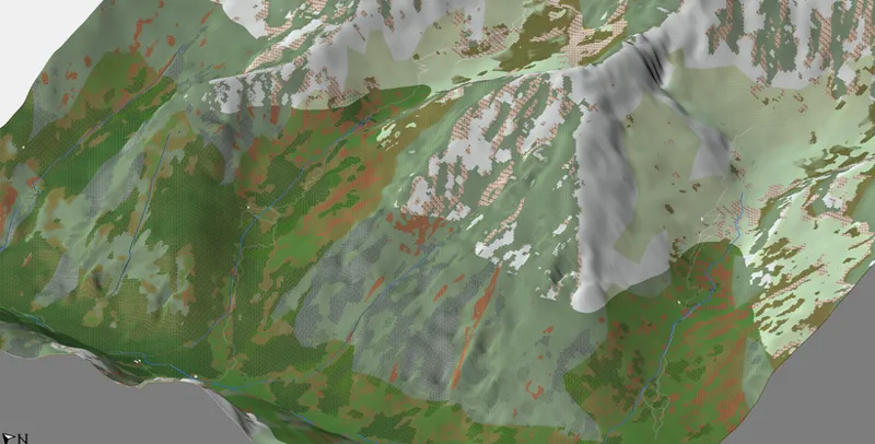
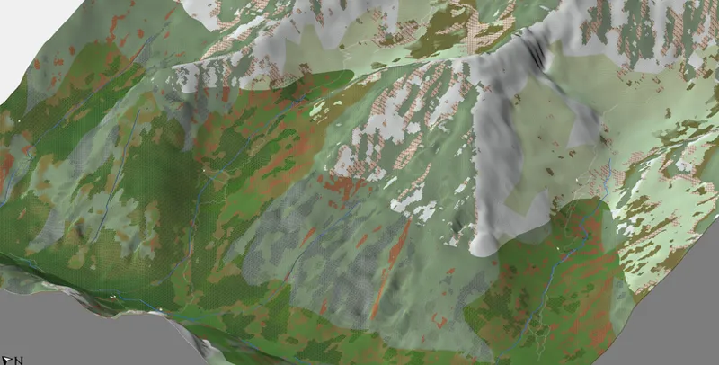
A 3D View from Worldpainter of a 1:10 scale Northern Corsica map with Terralith biomes
High-resolution DEM datasets for Europe and Canada
EarthToMC v2.0 adds support for 15 new high-resolution DEM sources covering many European countries, Canada, and Arctic regions. The software will automatically detect which high-resolution DEM is available for the area you're generating based on the country overlap and the selected map resolution:
Belgium (Flanders): 1m - 5m (Vlaanderen DHMVII DTM)
France: 1m - 5m (IGN RGE ALTI 2.0)
Germany: 1m (OpenDEM DTM)
Netherlands: 0.5m (AHN - Actueel Hoogtebestand Nederland)
Switzerland: 0.5m - 2m (Swisstopo SwissALTI3D)
United Kingdom: 1m - 2m (DEFRA LIDAR Composite DTM 2022)
Italy: 10m (INGV TINITALY v1.1)
Spain: 2m (CNIG MDT02 COG)
Canada: 1m - 2m (NRCAN HRDEM)
Arctic regions: 2m (PGC ArcticDEM v4.1 Mosaic)
This MASSIVELY improves the details of the terrain elevation on high resolution maps (1:1 to 1:10 scale) in those areas of the world.
Below an example on a 1:1 scale map of part of the Switzerland Alps
New SwissALTI3D 0.5m resolution DEM dataset
Old NASADEM 30m resolution DEM dataset
Another example on a 1:1 scale map of Marseille, France
New IGN RGE ALTI 1m resolution DEM dataset
Old NASADEM 30m resolution DEM dataset
WorldPainter biome previews
In previous versions, the map preview shown during generation was based on QGIS project rendering. In v2.0, previews are now generated directly from the WorldPainter .world files, showing the actual biome layers and terrain types as they will appear in the final Minecraft world.
After each tile is fully processed, a PNG image is automatically exported from the WorldPainter world file and displayed in the GUI in real time. This gives you immediate visual feedback of how the biomes look from a Minecraft perspective, without having to wait for the export to finish or open WorldPainter manually.
Per-tile build height limits optimization
EarthToMC v2.0 now computes the optimal build limit for each WorldPainter tile based on the local terrain elevation. Flat tiles use smaller world heights (eg: 256 or 320 blocks) while tiles with tall mountains use up to 1536 or 2032 blocks. This significantly reduces RAM usage during the WorldPainter export stage.
Maps History
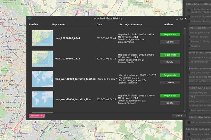
EarthToMC now keeps a record of every map you generate. You can access the full history via the "Launched Maps History" button, which shows a scrollable list of all your past maps with thumbnail previews and key metadata. You'll be able to configure EarthToMC to those map settings with a click, a lot of time saving!
Each entry can be viewed or deleted individually, and you can clean the entire history if needed
Your EarthToMC Stats
A new "My Stats" dashboard tracks your all-time usage of EarthToMC with lifetime statistics:
Activity stats: total app opens, maps launched, maps successfully generated, success rate
Usage stats: total generation time, total data downloaded, total blocks generated
Your preferences: most-used resolution, favorite country/continent, preferred biome mod, preferred Minecraft version
Stats are tracked automatically starting from v2.0 and will persist across future updates.
Deep ocean biomes and bathymetry improvements
For maps that use the bathymetry feature (sea/ocean depth from GEBCO 2024 data), a new "bathymetry cut at Y = -64" option clamps the ocean depth to match the Minecraft lower building height, preventing the bathymetry from going below the world limits.
Deep Ocean biomes are now properly assigned in areas where the ocean floor is deep enough. Few bugfixes causing artifacts near the coasts in certain types of map with bathymetry activated have been fixed.
Download post:
EarthToMC v2.0-beta [2026/03/08] - Download and Installation tutorial | Patreon
---
Full EarthToMC V2.0 changelog
Support for Minecraft Java 1.21.11
[NEW FEATURE] Massive redesign of the biome classification system, now distributed using WorldClim 2.1 climate data combined with higher resolution GLCFCS10 land cover data
[NEW FEATURE] Biomes O' Plenty mod support with 53 unique biomes
[NEW FEATURE] Terralith mod support with 71 unique biomes
[NEW FEATURE] Over 20 new vanilla biomes (such as Jungle, Savanna, Old growth pine/spruce Taiga, Birch forest) are now placed in the maps with geographic accuracy
[NEW FEATURE] Massive improvements in terrain elevation details for maps < 1:30 scale in Europe, Canada and Arctic regions using 15 new high-resolution DEM sources
[NEW FEATURE] Map previews are now generated directly from WorldPainter .world files instead of QGIS, showing the actual Minecraft biome layers and terrain types
[NEW FEATURE] Added a "Cut bathymetry at Y = -64" option to prevent bathymetry from going below standard world limits
[NEW FEATURE] Added a "Maps History" section that records every generated map with thumbnails and metadata for a more pratical re-generation of maps
[NEW FEATURE] Added a "My Stats" section that records lifetime statistics including total app opens, maps successfully generated, total generation time, data downloaded and more
Exporting maps with non-standard height limits is now faster and lighter on RAM Usage, since each tile will have its own build limits instead of a common max/min interval for all the tiles
WorldPainter .world files generation is now faster and lighter on RAM usage (before each wpscript "part" was loading/saving the world n times for each tiles)
Faster processing of continental low resolution maps (> 1:100 scale) using Natural Earth Data instead of OpenStreetMap data when possible
Added deep ocean biomes in maps that use bathymetry
Added a backup Sentinel-2 satellite imagery source (Copernicus Data Space Ecosystem) and a new download method from EOX for improved stability
Fixed few bugs in the bathymetry calculation that were causing artifacts near the coasts
Fixed a bug in the calculation of Estimated Time during worldpainter export stage
Fixed a bug in the calculation of Estimated Time and Progress bar after resuming a map
Fixed a bug potentially causing critical error 39 when generating maps with resolutions > 100m
Fixed a bug causing strange issues when changing dedicated ram in WSL settings in certain scenarios
Fixed a bug in USGS EarthData login for users that installed EarthToMC after 30/01/2026 leading to Error Code 12
Fixed a bug potentially causing critical error 79c when Sentinel data download fails
FULL CHANGELOG --> https://earthtomc.com/app/CHANGELOG.txt