




Introduction to MissionPlot: the Future of DCS Flight Planning?
One of the most obvious difference between civilian and military aviation probably lies in the planning cycle. I admit that my experience in the civilian world is limited: I earned my Private Pilot License as a teenager at a small flight club and later completed my Instrument Rating (IR) between two military flight schools. In both instances, flight planning was rudimentary. During my IR training, there was no real planning with my instructor, and the "briefing" was often little more than five minutes of cockpit chit-chat before taxiing.
This was a world away from the Air Force. In my operational experience, a standard flight required at least one hour of planning for every hour of flight time. When complexity or stakes increased, that ratio grew significantly, all before the formal briefing even began. Our primary tools were simple: a pencil, a few charts, aeronautical data (weather, airspace, NOTAMs, etc...), aircraft performance data, and intel info for tactical scenario.
Now, as a DCS enthusiast, I still find that I need this same structure to truly enjoy the experience. While I can jump into a jet for a quick set of BFM or an improvised low-level canyon run, those "gaming" moments don't provide the same satisfaction as a flight executed with serious preparation. But the question for our community has always been: what tools allow us to get that planning depth in DCS?
For a long time, as my previous articles suggest, CombatFlite was the definitive answer. Created by a military pilot specifically for DCS, it was a masterful tool. However, we must eventually acknowledge the reality of software lifecycles. The lack of long-term support has caused it to become obsolete. From broken mission editing features and unsupported aircraft to the "programming tricks" required just to make it recognize new theaters, CombatFlite is no longer the perfect fit for a modern DCS environment.
It became obvious that if we wanted a tool that truly met our operational needs, we would have to build it. This is where Quax stepped in. After being challenged repeatedly on his fuel management and execution during squadron flights, he began developing a performance tool to aid his tactical decision-making. He eventually offered to expand this into a comprehensive suite. That project has become MissionPlot.
Let’s take a look at why this software has become the most serious contender to replace the legacy tools of the past.
I - Disclaimer
MissionPlot is a paid software currently in active development.
Before we dive into the technical specifics, I want to be entirely transparent: I am not involved in MissionPlot financially. My role is strictly operational: I serve as a beta tester and have been involved in the design of unique features to ensure the software meets the high standards required for complex, multi-ship operations. My goal with this article is to demonstrate why moving beyond CombatFlite, and toward MissionPlot makes sense.
In short, I would say that MissionPlot isn't just a replacement for what we had: it is an effort to fill the widening gap between the mission editor and the virtual flight, centralizing performance data and navigation logic that was previously scattered across several disparate third-party tools.
II - Flight Path
Just to give you an idea on how MissionPlot tries to go beyond CombatFlite, here are a few improvements that have been introduced.
II.1 - Trajectory and Ground Track Fidelity
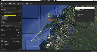
One of the most significant technical leaps in MissionPlot is its treatment of the aircraft’s actual ground track. When planning a high-speed ingress at low altitude, a turn is not a sharp angle: it is a curve defined by your true airspeed (TAS) and bank angle. MissionPlot calculates the turn radius to ensure that your planned path actually matches what the aircraft will fly.
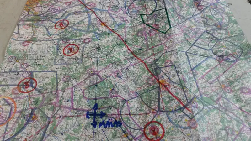
This feature addresses the specific difficulties often discussed by those trying to learn the "old way" of aviating. As highlighted by Karon on his Fly & Wire blog, the release of the Heatblur F-4 Phantom II reignited a widespread interest in low-level navigation using nothing more than a map, a compass, and a stopwatch.
The logistical hurdle for the averge virtual pilot, however, is significant: very few of us have the means to print a full-scale 1:500,000 aeronautical chart for the vast expanses of every DCS theater. MissionPlot provides us with both the cartography, measurement and drawing tools required for dead reckoning, effectively solving that problem without the physical constraints of a traditional paper chart.
The software also accounts for great circle navigation. While this might seem negligible on smaller maps like the Persian Gulf, it becomes factor for long-range sorties in large theaters, or on theaters near the poles, like Kola or South Atlantic. Due to the map projection system used in CombatFlite (EPSG:3857), there's a bit difference between what you plot on the map and what you'll actually fly in the air when you get closer to the poles. By calculating the shortest distance over the earth's curvature, MissionPlot provides a more accurate total distance, heading calculation, and consequently, a more precise time management tool, both solving the great circle and the projection issue at the same time.
Note: we totally understand that currently, DCS World is modeled as a "Fat Earth" and great circles are not to be taken into account yet. But, it means that by design MissionPlot is already compatible with a future "Curved Earth" DCS theater. Very shortly, you'll see an option to switch all calculations between "Flat Earth" and "Curved Earth".
II.2 - Waypoint Logic: Intercept to Reach
A unique feature within the navigation engine is the "Intercept to Reach" logic. Operationally, we often need to arrive at a specific waypoint, such as an Initial Point (IP), on a very specific heading and from a precise distance. This type of behavior is also consistent with the horizontal navigation mode on some autopilots.
Instead of the pilot manually "eyeballing" the turn-in point on a map, MissionPlot allows you to define the desired track and distance for the final segment. The software then calculates the necessary intercept geometry to put you on that line. This level of precision is essential when you start aiming TOT at the second...
III - Performance
One of the defining characteristics of combat aviation is the constant management of endurance. Unlike most civilian ferry flights, tactical sorties are designed to maximize playtime, which frequently pushes us to our absolute fuel limits. Serious mission planning requires knowing exactly how far and how long the aircraft can operate with the specific fuel load allotted to the task. While "cockpit math" and real-time fuel management should become second nature to any virtual pilot, a fuel planning tool is still very handy: it's a good way to refine your consumption figures against your intended route and flight profile, and help you make better mental fuel estimates in the long term.
We can note that such tools, like AMVI's DCSMP2, which provides excellent standalone calculations, already exist. However, there is to my knowledge no suite that integrates this high-fidelity performance data directly into the navigation and mapping environment. MissionPlot addresses this gap by placing the aircraft’s physical state (its weight, drag, and atmospheric performance) at the very center of its planning engine.
III.1 - Loadout Inventory and Weight/Drag Management
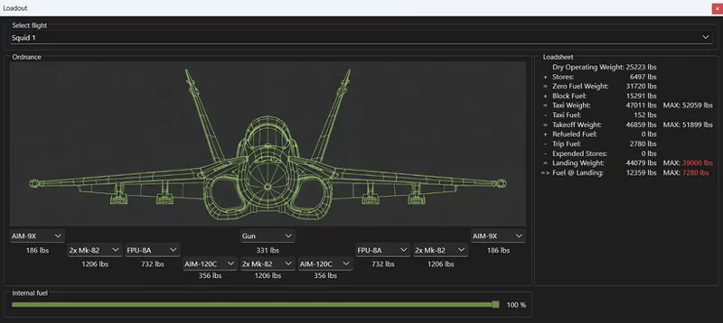
The performance calculation begins with the loadout inventory. This selection defines the aircraft's weight and Drag Index (DI): every pylon, missile rail, and bomb rack adds a specific weight and amount of aerodynamic resistance.
The software allows for a station-by-station loadout configuration that mirrors the DCS environment. By calculating the cumulative drag and weight of the selected stores, MissionPlot derives an instantaneous fuel flow for the planned flight altitude.
III.2 - Fuel Consumption
As you have probably discovered it now, for jet-powered aircraft, fuel consumption is a non-linear problem. To provide accurate data, the software takes into account fuel flow across three primary variables:
Altitude: as an aircraft climbs, the air becomes less dense. This reduces aerodynamic drag but also limits the oxygen available for the engines. There is always an "optimum" altitude for a given weight and drag index. On modern jets, these figures are displayed but the weapon system, but for older ones, you have to use performance graphs to determine them. Mission Plot uses data recorded in game to estimate your actual fuel flow at a given altitude.
Speed or Mach number: fuel flow is directly affected by your current speed, and for each altitude there's a "Max Endurance" and a "Best Range" speed that help you maximize performance. MissionPlot takes into account your planned speed to estimate your actual fuel needs.
Configuration: currently, the weight is the primary factor taken into account to estimate your fuel flow. In the future, drag index and configuration changes will be included, in order to refine even more your fuel consumption.
By integrating these variables into a single planning interface, MissionPlot enables you to make very precise fuel estimates: you have here an in-game data-driven prediction of your fuel state at every waypoint, ensuring that your tactical decisions are based on the actual constraints of the aircraft in the simulator.
III.3 - Decision Fuel
In addition to these standard fuel calculations, you also have a tool to help determining your BINGO fuel. Most of you are probably familiar with this concept: the BINGO fuel is the fuel that enables you to return to base with the minimum landing fuel. But in order to compute this fuel, you have to make various assumptions: do you have a mandatory exit point? what is the altitude profile in enemy territory? do you have a post-refueling tanker? etc...
Obviously, you need to understand how each of these profiles is built, and you'll often have to do different assumptions that are not defined as such, but these few pre-determined profiles are a perfect way to make quick estimates and check your own calculations!
IV. Various
There are plenty of other features that would deserved to be presented here, but that's impossible in the limited time I have for now...
So, you'lll find below a quick glimpse at what's already available:
already discussed here: a unique "DCS ISR" feature enabling a direct control of the external camera in DCS World, in order to simulate satellite pictures. In the future, the idea is to expand that feature, in order to defined a set of "collection points" that can be automatically retrieved in one click. In the long term, enabling the definition of these "collection points" dynamically in game, during the flight, would enable the simulation of recce flights.
In addition to web-hosted maps, like Google or OpenStreet maps, all .mbtiles maps created for CombatFlite are also usable in MissionPlot. A new map format has been added: it's called .pmtiles, and it's an improved type of map format, enabling the use of vector data in addition to raster tiles like .mbtiles.
the radio-preset tab will enable you to easily set-up your frequency plan.
many export formats will enable a direct export to DCS via the DTC system, or to third-party tools, like DCS-DTC, DCS data card builder, or digital kneeboard simulator.
a basic weapon delivery planner has been created in order to determine low drag bomb trajectories. This tool will be expanded in the future to be fully integrated within the flight plan, and allow for complex attack profiles (like pop-up).
Conclusion
The primary objective of this overview was to encourage you to try MissionPlot by yourself.
However, I must remain objective: MissionPlot is still a work in progress. There are still sectors where it has yet to reach the maturity or feature density that CombatFlite offered. Specifically, complex multi-ship coordination features, such as the replay and synchronization options we relied on in the past, are still being worked on. Similarly, the automated data-card generation is not yet here...
If you find value in this tool and wish to see it evolve into the definitive DCS planning suite, don't hesitate to get involved personally. You can support Quax and the MissionPlot project in two very direct ways:
first, by reporting any bugs or edge cases you encounter during your mission planning.
second, by clearly defining and describing the additional features you require for your specific mission profiles. In particular, if you're a slow-mover or helicopter pilot, you might need specific features that we don't know about...
Thank you in advance for your help!
Comments (4)
C'est un super soft. J’essaie d'aider à mon humble niveau Quax pour lui donner des pistes de travail.
Do you know if we can directly load mission files into the application? At the moment, I've only seen an option to import combatflight files
Hi, yes miz file import is still work in progress, but it should be coming relatively rapidly.
Thanks for the write-up on this soft ware